Entry Points:

About U.S. Highway 6
U.S. Highway 6 runs from the tip of Cape Cod, in Massachusetts, to Bishop, California, a distance of 3,205 miles. For nearly thirty years, it had the distinction of being the longest U.S. Highway at 3517 miles, when it ran to the Pacific Coast at Long Beach. But in 1964, it was truncated to its present ending not far from the California-Nevada border. When the route was originally designated in 1926, it ran only from Cape Cod to Erie, Pennsylvania. In 1932 it was extended to Greeley, Colorado, and in 1937, it was extended again to Long Beach. It also passes through Rhode Island, Connecticut, New York, Pennsylvania, Ohio, Indiana, Illinois, and Nebraska.
U.S. Highway 6 has been known as the "Grand Army of the Republic Highway".
What to See along Highway 6
UntraveledRoad includes three segments of U.S. Highway 6 in the deserts of Colorado, Utah and Nevada, as well as segments of old alignments replaced by freeways.
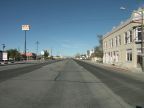
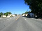
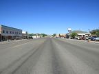
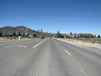
Lynndyl, Utah to Ely, Nevada
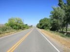
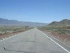
Lynndyl lies near the Sevier River in the Sevier Basin, the seafloor of ancient Lake Bonneville. It passes in a southwesterly direction through settlements that were made along the Sevier River, of which Delta is the major one. At Delta, Highway 6 joins U.S. Highway 50, and the two are combined all the way to Ely. The Sevier River dries out and the highway takes a long straight line through the desert to pass around the south end of the House Range of mountains. It then crosses Tule Valley, a shorter, slightly less desolate area, and climbs Kings Canyon into the Confusion Mountains. Kings Canyon is lined with impressive cliffs, but sports little vegetation. Snake Valley lies to the west of the Confusion Mountains, another large, empty valley, which is graced by the Wheeler Peak, a 13,000-foot peak in Great Basin National Park, which overlooks the valley from the west side. After crossing into Nevada, and passing the junction with Nevada Highway 487, U.S. Highway 6 climbs the Snake River Mountains, with Wheeler Peak to the south. After this it drops into Spring Valley. On the west side of Spring Valley, it comes to Major’s Junction, where it meets U.S. Highway 93, which is also combined with it to Ely. The combined route climbs the Schell Creek Range and enters Steptoe Valley. Steptoe Valley is higher than the preceding valleys, and the scenery here is somewhat greener. The highway turns north in Steptoe Valley until it reaches Ely. At Ely all three routes break into separate directions.
Wellington to Interstate 70 in Utah
Beginning on the west side of Wellington, U.S. Highway heads southeast and passes through a scenic desert area, decorated with hills of colored earth and rocky outcroppings, and overlooked by the Book Cliffs. After about 55 miles, it reaches interstate 70 at a junction just a few miles from Green River.
Fruita to Mack, in Colorado
The section of U.S. Highway 6 running from Fruita to Mack lies in Grand Valley of Colorado, an agricultural area supplied with irrigation water from the Colorado River. Here the highway parallels Interstate 70 providing access to these rural areas. The Colorado River passes by just south of Fruita, and then heads into a hilly area on the south side of the valley. Near Mack, the limits of irrigation are reached, and the land becomes desolate; so traffic from Highway 6 is directed onto the freeway. This segment is only about eight miles long. However, the old highway 6, in an increasingly dilapidated form, continues into Utah, another twenty miles or so to a point where it disappears under current-day Interstate 70. This entire section is overlooked by the Book Cliffs to the north. The cliffs of Colorado National Monument are also visible to the south of Fruita.
Green River and eastward
From Green River eastward, U.S. Highway 6 is combined with Interstate 70 all the way to Mack. Along this stretch, portions of the old highway are extant. The Main Street of Green River today is called Utah Highway 19, and it was originally Highway 6 & 50, beginning at the interchange west of town. On the east side of Green River, highway 19 curves south to the freeway, but the old highway breaks off and passes through the desert below the Book Cliffs to the Ruby Ranch Road interchange on I-70. Several miles further east, old Highway 6 reappears at Crescent Junction, passes through Thompson Springs, and reaches another interchange with I-70. This area is a popular area for four-wheeling. Drives up canyons, into the Book Cliffs on remote dirt roads, can be very scenic.
Iowa
A stretch of old Highway 6 can be viewed in Iowa from Anita to Wiota. This is an area of rolling hills covered with farmland and grass and occasional thickets of trees.
For More Information
See the Wikipedia U.S. Highway 6 article.