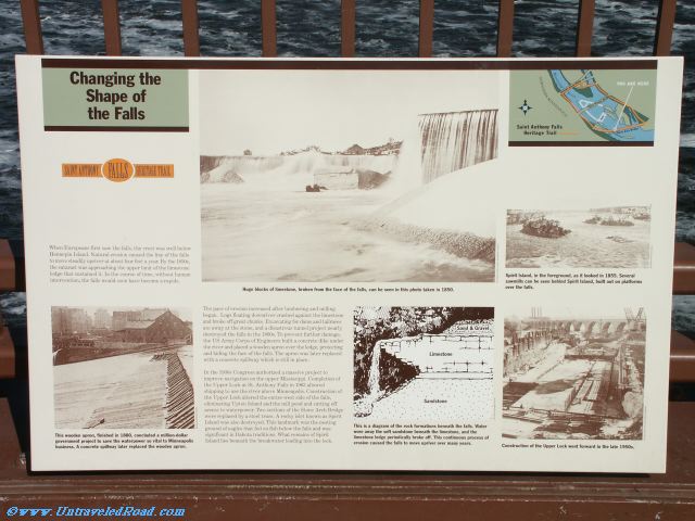
Changing the Shape of the Falls
Saint Anthony Falls Heritage Trail
When Europeans first saw the falls, the crest was well below
Hennepin Island. Natural erosion caused the line of the falls
to move steadily upriver at about four feet a year. By the 1850s,
the cataract was approacing the upper limit of the limestone
ledge that sustained it. In the course of time, without human
intervantion, the falls would soon have become a rapids.
The pace of erosion increased after lumbering and milling
began. Logs floating downriver crashed against the limestone
and broke off great chunks. Excavating for dams and tailraces
ate away at the stone, and a disastrous tunnel project nearly
destroyed the falls in the 1860s. To prevent further damage,
the US Army Corps of Engineers built a concrete dike under
the river and placed a wooden apron over the ledge, protecting
and hiding the face of the falls. The apron was later replaced
with a concrete spillway which is still in place.
In the 1930s congress authorized a massive project to
improve navigation on the Upper Mississippi. Completion of
the Upper Lock at St. Anthonay Falls in 1963 allowed
shipping to use the river above Minneapolis. Construction of
the Upper Lock altered the entire west side of the falls,
eliminating Upton Island and the mill pond and cutting off
access to waterpower. Two sections of the Stone Arch Bridge
were replaced by a steel truss. A rocky islet known as Spirit
Island was also destroyed. This landmark was the nesting
ground of eagles that fed on fish below the falls and was
significant in Dakota traditions. What remains of Spirit
Island lies beneath the breakwater leading into the lock.
This wooden apron, finished in 1880, concluded a million-dollar
government project to save the waterpower so vital to Minneapolis
business. A concrete spillway later replaced the wooden apron.
This is a diagram of the rock formations beneath the falls. Water
wore away the soft sandstone beneath the limestone, and the
limestone ledge periodically broke off. This continuous process of
erosion caused the falls to move upriver over many years.
Spirit Island, in the foreground, as it looked in 1855. Several
sawmills can be seen behind Spirit Island, built out on platforms
over the falls.
Construction of the Upper Lock went forward in the late 1950s.