Beneath the Surface
Saint Anthony Falls Heritage Trail
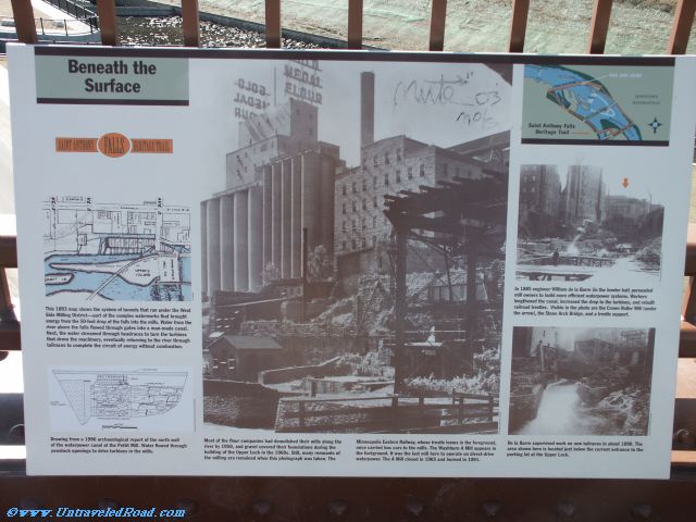
This 1893 map shows the system of tunnels that ran under the West
Side Milling District--part of the complex waterworks that brought
energy from the 50-foot drop of the falls into the mills. Water from the
river above the falls flowed through gates into a man-made canal.
Next, the water streamed through headraces to turn the turbines
that drove the machinery, eventually returning to the river through
tailraces to complete the circuit of energy without combustion.
Drawing from a 1996 archaeological report of the north wall
of the waterpower canal at the Pettit Mill. Water flowed through
penstock openings to drive turbines in the mills.
Most of the flour companies had demolished their mills along the
river by 1950, and gravel covered their foundations during the
building of the Upper Lock in the 1960s. Still, many remnants of
the milling era remained when this photograph was taken. The
Minneapolis Eastern Railway, whose trestle looms in the foreground,
once carried box cars to the mills. The Washburn A Mill appears in
the foreground. It was the last mill here to operate on direct-drive
waterpower. The A Mill closed in 1965 and burned in 1991.
In 1885 engineer William de la Barre (in the bowler hat) persuaded
mill owners to build more efficient water power systems. Workers
lengthened the canal, increased the drop to the tirbines, and rebuilt
railroad trestles. Visible in the photo are the crown Roller Mill (under
the arrow), the Stone Arch Bridge, and a trestle support.
De la Barre supervised work on new tailraces in about 1890. The
area shown here is located just below the current entrance to the
parking lot at the Upper Lock.