The Mississippi River
The Mississippi River is one of
the largest rivers in the world. It
divides east from west through
the center of the United States:
boundary, obstacle, water supply,
drainage system, highway. it is
2,350 miles long and flows from
Lake Itasca in northern Minnesota
southward to New Orleans and
the Gulf of Mexico. Its watershed
covers 1,231,000 square miles
and drains portions of thirty-two
states and two Canadian
provinces.
Wild and natural resources
abound in the river corridor.
Forty percent of North American
waterfowl migrate along its
flyway. As a major mid-continent
waterway, the Mississippi has
carried people and products
north and south over thousands
of years.
The river has stirred imagination
and creativity in the worlds of art,
music, dance, and literature.
Stories of human time and habitation
are found in cities and in
open spaces; in bridges, dams,
and navigation systems, in houses,
farms, and industrial buildings;
in parks, burial grounds, and
archaeological remains. They are
stories of places and people who
have known and lived near the
Mississippi, past and present.
The Falls of St. Anthony
The Falls of St. Anthony is
the only major waterfall on the
Mississippi River. It has meant
many things to people over time:
a place of wonder and mystery;
a landmark for travelers, explorers,
traders and tourists, a
waterpower harnessed by early
industrialists to produce wealth,
power, and international fame
for the region.
The fallswere not always where
they are today. Over many centuries,
forces of erosion caused
them to move upstream to their
present location, where they
were stabilized in the 1870s to
protect the waterpower for the
growing city of Minneapolis.
That pathway of erosion defined
the geography of the Twin Cities.
S. Paul was settled in the 1840s
at the head of steamboat navigation
on the Mississippi, near the original
site of the falls some 12,000 years
ago. It became the territorial capitol
of Minnesota in 1849 and the state
capitol in 1858.
Minneapolis, twelve miles upstream
from St. Paul, developed in the
1850s around the waterpower of
the falls, to become the flour-
milling capitol of the nation from
1880 to 1930 and the largest city
in Minnesota today.
Layers of History
The Falls of St. Anthony is the only true waterfall on the 2,350-
mile length of the Mississippi. It has eroded upriver many miles in
the 12,000 years since humans first saw it. The falls then may have
been as much as two miles wide and 200 feet high, swollen by
melting glaciers. The single token found from those ancient people
is a flaked stone spear point, picked up on the river bank by a
20th-century archaeologist.
The Dakota called the Mississippi River, Hahawakpa, "river of the
falls." The falls were first seen by Europeans in 1680 when Louis
Hennepin, a Catholic friar in the service of France, viewed them from
this bluff. Hennepin was brought to the falls by the Dakota, and he
watched while they listened to the voices of unseen spirits in the
roaring water and made reverent offerings. The priest then crossed
himself and named the falls for a Christian saint - Anthony of Padua.
Over the next 150 years, traders, soldiers, missionaries, and artists
spread the fame of the cataract's majesty and beauty. For speculators
and businessmen, however, it held a different kind of fascination.
Today the falls, the islands, and the river banks hold layer upon
layer of testimony to changing human use. Three islands are gone.
Dams divert some of the river's flow into a power plant. A concrete
spillway replaces the limestone cliff over which the water once poured.
On the west side, locks lift barges into the Minneapolis Upper Harbor.
Far above the current, city traffic rumbles across bridges, while in
parkland along the banks, the remains of an earlier industrial era lie
beneath trees, grass, and gravel.
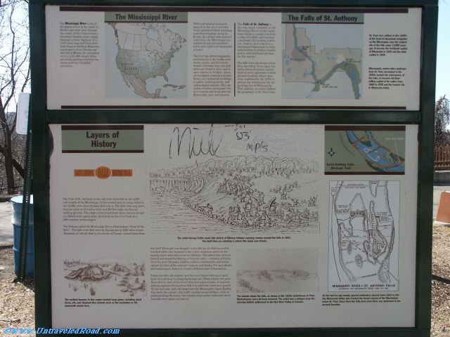
The artist George Catlin made this sketch of Ojibway Indians carrying canoes around the falls in 1841.
The bluff they are climbing is where this kiosk now stands.
The earliest humans in this region hunted large game, including giant
bision, elk, and elephant-like animals such as the mastadon or the
mammoth shown here.
The islands below the falls, as shown in the 1820s sketchbook of Peter Rindisbacher, have all been removed. The artists was a refugee from the
starving Selkirk settlement in the Red River Valley in Canada.
As the last ice age ended, glacial meltwaers poured down what is now
the Minnesota Valley and created the broad canyon of the Mississippi
below St. Paul. Since then the falls have wore their way upstream to the
present location.