Entry Points:

About Sitka
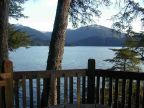
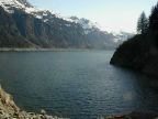
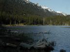
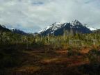
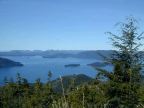
The Borough of Sitka comprises the whole of Baranoff Island, a 100 mile long island in the panhandle of Alaska. The coastline is lined by steep mountains which rise to glacier-covered peaks. Temperate rainforests cover the land down to the water's edge and the ground is covered with moss and other water-loving plants. Streams flow everywhere and flat areas turn into swamps called muskeg. The landscape is frequently shrouded by clouds and mist.
Sitka itself occupies a spot on the west side of the island. The Tongass National Forest covers all the island except the inhabited area around Sitka. Despite the fact that the whole borough is technically part of the city, the rest of the island is virtually uninhabited. Highways extend along the coast about seven miles in each direction from Sitka and a few other small roads extend further.The Halibut Point Highway goes north from Sitka to the location of the original Russian settlement, called Old Sitka. Sawmill Creek Road runs about eastward to where the old pulp mill is located and two other roads lead from there to Blue Lake and southward along the coast. The O'Connell bridge crosses the water from downtown Sitka to Japonski Island where the community of Mount Edgecumbe and the airport are located. Sitka National Historical Park, called Totem Park by the locals, is in the southeast part of Sitka, and includes the site of Fort Shiskeenue.
Mount Edgecumbe is a volcano prominently visible in Sitka, located across the water on another island.