Entry Points:

About San Juan County

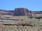
San Juan County, located in the southeast corner of Utah, is an arid land shaped by the Colorado River which forms its western border. Cutting through an ancient seafloor, the river dug a gorge thousands of feet deep. Just thirty miles east of the river stand the Abajo Mountains, reaching above 11,000 feet in elevation and some 8000 feet above the water level below. This tremendous difference in elevation, combined with the arid climate, has produced a terrain tortured by steep slopes, narrow canyons, cliffs and yawning chasms.

Mormon pioneers made the difficult crossing into this area from 1878 to 1880, arriving in Bluff first and settling Monticello in 1888. On the east side of the Abajo Mountains they found farmland which had not been carved up and eroded by the river, as well as water flowing from the mountains.

It occupies the large area of 7,725 square miles with a population density of fewer than 2 persons per square mile. Towns are small and far apart. In ancient times the area was inhabited by Indians who left their traces at Hovenweep National Monument and locations scattered throughout the area.

Rainbow Bridge, Lake Powell and Canyonlands National Park are popular tourist attractions in San Juan County.


Street Index


1300 North Street
3000 North Street
a dirt road
a road
a shoreline
Bayles Road
Bill Hollow Road
Blue Mountain Ranch Road
Blue Mountain Road
Brushy Basin Road
Comb Ridge
Comb Wash Road
County Route 144
County Route 147
County Route 204
County Route 215
County Route 235
County Route 247
County Route 262
County Route 2691
County Route 275
County Route 293
County Route 307
County Route 308
County Route 309
County Route 311
County Route 312
County Route 314
County Route 335
County Route 350
County Route 355
County Route 364
County Route 366
County Route 377
County Route 378
Douglas Wash Road
Five Kiva Pueblo Trail
Harts Draw Road
Harts Point Road
Horsehead Drive
Hulkito Wash Road
Landfill Road
Lime Creek Road
Long Canyon Road
McElmo Canyon Road
McElmo Creek
Mexican Hat Rock Road
Montezuma Canyon Road
Monument Valley Road
Nations Natural Bridge Trail
Newspaper Rock
Old Highway
old road
Oljeto Road
Phantom Drive
Pinion Ridge Drive
Pinion Ridge Road
Radio Hill Road
Recapture Recreation Area Road
Reservoir Road
Ruin Road
Sagebrush Road
San Juan River
State Highway 162
State Highway 211
State Highway 261
State Highway 262
State Highway 275
State Highway 276
State Highway 46
State Highway 95
Taylor Lane
La Sal Mountains
Trading Post Road
U.S. Highway 163
U.S. Highway 191
U.S. Highway 491
Valley of the Gods Road
Verdure Lane
Water Road
West Summit Road
Westwater Creek Road
White Canyon
White Mesa Road
Wilson Arch

TERMS + CONDITIONS | COPYRIGHT 1999-2016 UNTRAVELEDROAD