Entry Points:

About Keystone
Between the forested slopes of Battle Creek Canyon, Keystone began in 1883 as a mining town. The rugged Black Hills country stretches for miles around the town, with a generous covering of evergreen trees, grass and undergrowth. Rocky outcroppings protrude from the forest frequently and cliffs stand alongside tall trees at the edge of the canyon.
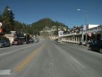
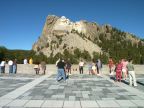
In 1927, Keystone became the center for a new activity in the Black Hills when the carving of Mount Rushmore began. For fourteen years, Keystone was the home of as many as 400 workmen who worked with jackhammers and dynamite to remove vast amounts of stone to reveal the faces of four great American presidents. Upon completion, Keystone transformed into a resort town catering to the millions of visitors to the memorial annually. Keystone's population is 311 (as of the year 2000).
The boundary of Mount Rushmore National Memorial extends to the edge of Keystone, which is just a couple miles away. U.S. Highway 16A passes through Keystone, lined with hotels and tourist attractions. A short distance south of the town, South Dakota highway 244 intersects, leading up to the sculpture site, with route 16A continuing southward into the Black Hills.
Street Index
|
Old Hill City Road Reed Street State Highway 244 |