Entry Points:

About Grand Teton
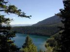
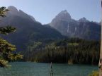
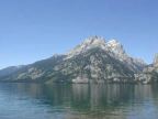
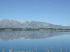
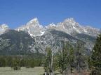
The Grand Teton towers a mile above its reflection on the surface of Jenny Lake, which lies at its base. Evergreen forests surround the lake and the mountain, above which the white speckled stone of the peak sparkles in the sky. Streams of cold water flow from glaciers nestled between mountain peaks into Jenny Lake and a half dozen other lakes at their base. Further out in the valley, the Snake River flows through thickets of willows, sagebrush flats and groves of trees. Deer graze on the grass under the trees.
At 13,770 feet in elevation above sea level, the Grand Teton is the tallest of the range of mountain peaks that rise abruptly along the western side of the valley called Jackson Hole. Twelve other Teton peaks reach above 12,000 feet in elevation. A dozen glaciers still cling to the peaks, remnants of a past ice age, whose force excavated the lakes at their base.
The Grand Tetons became a national park on February 26, 1929. It covers 107,619 acres and was visited by 2,680,025 people in 1999. It lies a short distance south of Yellowstone National Park and a pass for one admits you to the other also.
The pristine lakes are a treasure in themselves, and include Phelps Lake, Taggart Lake, Jenny Lake, String Lake and Leigh Lake.
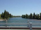
The 15 mile long Jackson lake covers a significant part of the park, being a reservoir formed by the Jackson Dam.
For More Information:
See the National Park Service's official Grand Teton National Park site, or Wikipedia's Grand Teton National Park article.