Entry Points:


About Coconino County
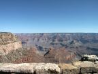
Coconino County, home of the famed Grand Canyon, covers 18,608 square miles of central northern Arizona, making it the second largest county in the United States, with three times the land area of Delaware.
The Grand Canyon cuts through a high plateau which, beyond the cliffs of the canyon, is largely flat. To the south, the Coconino Plateau stretches to the San Francisco Peaks and other volcanic mountains along the southern boundary of the county. Along the south rim, the plateau tips upward far enough that winter snows support forests of Junipers and evergreen trees. To the north, the Kaibab Plateau rises gently above the surrounding plateaus, reaching to 9,000 feet in elevation, where heavy forests and alpine meadows can be seen. To the east of the Grand Canyon, the Painted Desert lies at a lower level, and being extremely arid, exhibits colored hills of earth in pink, purples and green. The Echo Cliffs, of red Navajo sandstone, rise to the east, and the Vermillion Cliffs, with a littering of boulders at their base, flank the northern horizon.
Flagstaff, the county seat, and major population center, sits below the southern slopes of the San Francisco Peaks. Contrasting the yellow grass and Junipers of the plateau to the north, the San Francisco Peaks enjoy a thick forest of Ponderosa Pines, which extend southward to the Mogollon Rim. Reaching to 12,633 feet in elevation, the San Francisco Peaks are the highest point in Arizona.
The 277-mile-long Grand Canyon, coupled with its hundreds of cliff-lined side canyons, has always proved a formidable obstacle to travel. Between Hoover Dam, on the California border, and the Navajo Bridge at Marble Canyon, no road attempts a crossing. Many areas along the canyon rim are extremely remote and seldom visited.
Coconino County was formed in 1891. As of the year 2000, the population stood at 116,320. Interstate 40 passes through the southern part of the county, following the route of Historic Route 66. U.S. Highway 89 travels north from Flagstaff into House Rock Valley, where it divides into two separate routes. The main route climbs the Echo Cliffs northward into Utah, while the alternate route follows the base of the Vermillion Cliffs to the Kaibab Plateau, where the North Rim of the Grand Canyon can be accessed. From there it continues on to Fredonia. U.S. Highway 160 exits the county on the east side, and Interstate 17 heads south from Flagstaff towards Phoenix.
For More Information:
See the Wikipedia article on Coconino County and the Coconino County Website.
Street Index
|
a dirt road a road a trail a turnout F.S. Route 600 |
F.S. Route 644 F.S. Route 776 F.S. Route 9122 F.S. Route 9137 Loop Road |
Painted Desert Vista State Highway 64 Little Colorado River Gorge |