Entry Points:


About Arizona
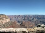
Arizona features a variety of scenery and topography. None is more famous that the 277-mile-long Grand Canyon which cuts a mile deep into the layered rocks of northern Arizona's Coconino Plateau. The 12,000-foot San Francisco Peaks tower over the southern edge of the Coconino Plateau, capped by Humphrey's Peak at 12,633 feet in elevation. Forests of Evergreen trees surround the San Francisco Peaks and extend towards the southeast, following Mogollon Rim. Forests can be found in other places at high elevations in the northern and eastern parts of Arizona, including the rim of the Grand Canyon. Lower areas are covered with Juniper trees and at lower elevations, the colors of the soil and rock are often exposed to view.
Moving towards the southwest portion of Arizona, Mogollon Rim over looks a steep drop in elevation to the dry and hot Sonoran Desert. Saguaro National Park and Organ Pipe Cactus National Monument preserve significant Sonoran Desert wildlands. Here, creosote bushes cover much of the land, with saguaro cactus, cholla cactus and other desert plants in some areas. Barren, rocky mountains jut out abruptly from the ground.
Before the Mexican War in 1848, Arizona was part of Mexico. At the end of the war, the United States took everything north of the Gila River. In 1853, the United States purchased the portions of Arizona south of the Gila River in the Gadsden Purchase. At about this time, Mormon pioneers, coming from Utah, began colonizing much of Arizona, including Phoenix Valley, Prescott and Snowflake. In 1863, Arizona was organized as a territory, and on February 14, 1912 it became the 48th state of the union. Arizona covers 113,909 square miles. As of the year 2000, the population is 5,307,331.
Historic Route 66 passed through Arizona, passing through Holbrook, Flagstaff and Kingman. Today it has been replaced by Interstate 40, but some stretches of the old highway can still be seen. Interstate 10 traverses the southern part of the state, connecting Phoenix and Tucson with New Mexico and California. Interstate 17 travels north to south from the Mexican border to Flagstaff.
Arizona is bordered by California on the west, Utah on the north, New Mexico on the east, and a bit of Nevada at the northwest corner. Mexico lies to the south.
For More Information:
See Wikipedia's Arizona page.
|

|