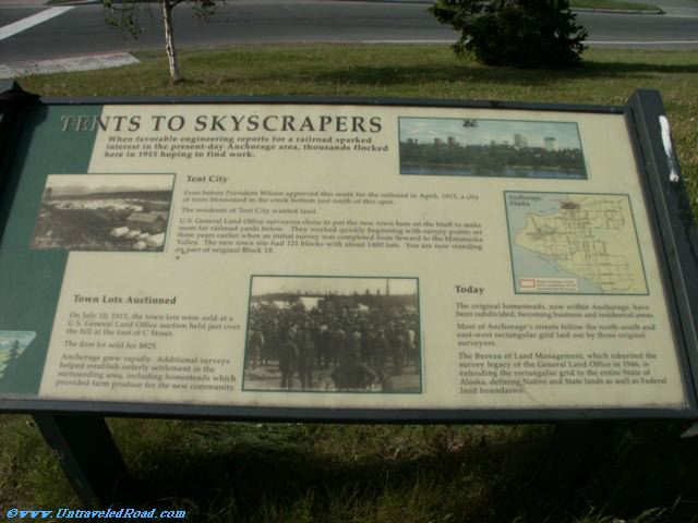
Tents to Skyscrapers
When favorable engineering reports for a railroad sparked
interest in the present-day Anchorage area, thousands flocked
here in 1915 hoping to find work.
Tent City
Even before President Wilson approved this route for the railroad in April, 1915, a city
of tents blossomed in the creek bottom just north of this spot.
The residents of Tent City wanted land.
U.S. General Land Office surveyors chose to put the new town here on the bluff to make
room for railroad yards below. They worked quickly beginning with survey points set
three years earlier when an initial survey was completed from Seward to the Matanuska
Valley. The new town site had 121 blocks with about 1400 lots. You are now standing
on part of original Block 18.
Town Lots Auctioned
On July 10, 1915, the town lots were sold at a
U.S. General Land Office auction held just over
the hill at the foot of C Street.
The first lot sold for $825.
Anchorage grew rapidly. Additional surveys
helped establish orderly settlement in the
surrounding area, including homesteads which
provided farm produce for the new community.
Today
The original homesteads, now within Anchorage, have
been subdivided, becoming business and residential areas.
Most of Anchorage's streets follow the north-south and
east-west rectangular grid laid out by those original
surveyors.
The Bureau of Land Management, which inherited the
survey legacy of the General Land Office in 1946, is
extending the rectangular grid to the entire State of
Alaska, defining Native and State lands as well as Federal
land boundaries.