Entry Points:

About U.S. Highway 95
U.S. Highway 95 traverses the Rocky Mountain area from Eastport, Idaho on the Canadian border to San Luis, Arizona on the Mexican border. It follows the Idaho panhandle southward, staying close to the Washington border, then passes through the southeast corner of Oregon. It traverses the entire length of Nevada, entering California near the southernmost tip of Nevada. From there it parallels the Colorado River, first on the California side, then on the Arizona side.
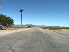
Few U.S. highways pass through so much desert as highway 95. In southern California and Arizona, it passes through the Mojave and Sonoran Deserts, lined with ocotillos and cholla cactus. Mountains of barren rock stand on the horizon. In Nevada it passes through the salt flats of ancient inland seas. In Oregon, sagebrush surrounds it. The California segment of it has been called "the lonliest highway in California."
The original route in 1926 consisted of a segment from Weiser, Idaho to the Canadian border. In 1940, it was extended southward through Nevada and California to Blythe. In 1961 the final addition was made from Blythe to the Mexican border.
What to See on Highway 95
In California, travel through the deserts near the Colorado River between Blythe and Needles, about a hundred miles in distance. Watch for ocotillos blooming in the area south of Needles, which was photographed on a beautiful April day.
In Nevada you can see a segment of Highway 95 passing by Death Valley National Park, beginning at Beatty and ending at Scotty's Junction.
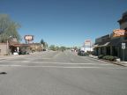
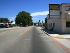
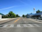
In Idaho a segment has been photographed in the farmland of the Snake River Basin, beginning near Marsing and continuing to Parma.
For More Information
See the Wikipedia U.S. Highway 95 article.