Entry Points:


About U.S. Highway 395
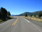
U.S. Highway 395 runs north and south from the Canadian border near Laurier to the interchange with Interstate 15 near Hesperia, a distance of 1305 miles. It passes through the states of California, Nevada, Oregon and Washington. Before the construction of Interstate 15, it extended further south to San Diego.
What to See along Highway 395
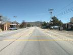
UntraveledRoad includes over 200 miles of Highway 395 in California and Oregon, the longest stretch running from Lakeview, OR, to Silvies Valley, a distance of some 200 miles. A stretch of about twenty miles shows the Mohave Desert in California from Trona Road, near Johannesburg, CA, to China Lake Blvd, near Ridgecrest, and a seven-mile stretch from Lee Vining to the junction of State Highway 167 passes Mono Lake, passing along base of the Sierra Nevadas. A short stretch is also available at Bridgeport, CA.
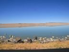
Lake Abert and Abert Rim
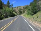
Lake Abert lies in the deserts of central Oregon, a bright patch of blue in the middle of an otherwise desolate scene. It is about 14 miles long. The Abert Rim is one of the highest fault scarps in the United States, rising 2,500 feet above Lake Abert on the east. The steep, boulder-strewn slope rises abruptly from the edge of the water, capped at the top with a 250-foot cliff of volcanic rock. U.S. Highway 395 winds its way between the water and the steep slope, and the scenery, despite being very barren, is striking.
Devine Canyon and Ridge
Just north of Burns, Oregon, Highway 395 enters Devine Canyon and crosses Devine Ridge, in the midst of one of the largest forests of Ponderosa Pines in America.
For More Information
See the Wikipedia U.S. Highway 395 article.