Entry Points:

About Bryce Canyon
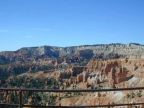
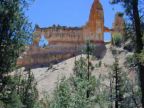
At Bryce Canyon, trails wind among spires, fins, pinnacles, mazes, collectively knowns as "hoodoos." Etched from cliffs of orange, red and cream-colored sedimentary stone, the formations line numerous small canyons cutting into the edge of the Paunsaugunt Plateau. The plateau's rim offers an overview of the whole lacy panorama of stone formations.
Along the rim of the plateau, the Rim Trail gives an overlook of the unique scenery.
Recognizing its natural beauty, Bryce canyon was designated a national park on September 15, 1928. It covers 35,835 acres. In 1999 there were 1,081,521 visits to the park.
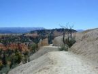
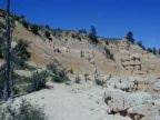
The road enters the park on the plateau above and many viewpoints on the rim are accessible by car. Numerous trails lead down among the formations themselves. The main trails are the Fairlyland Trail, Queens Garden Trail, Navajo Loop Trail and the Peekaboo Loop Trail. The viewpoints are Sunrise Point, Sunset Point, Inspiration Point and Bryce Point.
On UntraveledRoad you can follow the full 8 miles of the Fairlyland Loop Trail and the Rim Trail from the Fairyland Trailhead to Sunrise Point.
For More Information:
See the National Park Service's official Bryce Canyon National Park site, or Wikipedia's Bryce Canyon National Park article.