Entry Points:

About Badlands
Surrounded by the grass-covered prairies of South Dakota, a series of muddy, colored hills extend for some sixty miles. Badlands is not a new name for them. Lakota Indians called them mako sica and early French trappers called them mauvais terres a traverser, both meaning "bad lands." While ranchers graze their cattle just outside the park boundaries, and green grasses grow to the edge of the hills, these slopes are barren and the materials and geologic history of the terrain is exposed to view.
The casual visitor to the Badlands will see many hills of an off-white color, tinged with pink or purple, and fewer hills of yellow and dashes of other color scattered around. But geologists have identified 87 layers of sedimentary soil depositied in prehistoric times. Fossils have been studied and a geologic history has been deduced. But for most visitors it is a place of quietness and reflection.
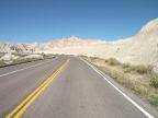
The Badlands were established as a National Monument on January 25, 1939, and became a National Park on November 10, 1978. 242,756 acres are included in the park boundaries, many of which are a roadless wilderness, and many of which are jointly administered with the Oglala Sioux Tribe, lying within their Reservation. A short drive from Interstate 90 brings visitors to the main parts of the park. Badlands Loop Road (State Highway 240) passes along the rim of the hills, connecting to Interstate 90 at both ends. 872,968 people visited the park in 2003.
For More Information:
See the National Park Service's official Badlands National Park site, or Wikipedia's Badlands National Park article.